Snowman Trek

Snowman Trek

Snowman Trek is a famous high-altitude trek in Bhutan, located in the eastern part of the country. It is a challenging trek that takes you through some of the most remote and beautiful landscapes in Bhutan. The trek covers a total distance of approximately 220 kilometers and takes around 21 days to complete. It takes you to the highest point of Bhutan, the pass of the Gangkhar Puensum (7,570 meters), which is also considered the highest unclimbed peak in the world.

The trek begins in Paro and takes you through the beautiful landscapes of Bhutan, including dense forests, rolling hills, and glaciers. You also get to see some of the most beautiful villages, temples, and monasteries along the way. The Snowman Trek offers stunning views of the Himalayas and its peaks, including Jhomolhari, Gangkhar Puensum, and others.


This trek is suitable for experienced trekkers and those who are physically fit, as it involves walking at high altitudes and in remote areas for extended periods. It is also a cultural experience, as you get to interact with the local people, learn about their traditions and culture, and enjoy some of the best food in Bhutan.

In conclusion, Snowman Trek is a once-in-a-lifetime experience that takes you through some of the most remote and beautiful landscapes in Bhutan. It is a challenging trek, but it offers a unique cultural and adventure experience that is worth every step.

Major Highlights

Scenic Beauty: Snowman Trek offers stunning panoramic views of the Himalayan range and valleys, surrounded by towering peaks and glaciers.

Cultural Experience: Trekkers can experience Bhutanese culture and tradition along the way, as they cross villages and interact with local communities.

Wildlife and Flora: The trek takes you through diverse ecosystems, offering the opportunity to observe unique flora and fauna along the way.

Solitude and Tranquility: The Snowman Trek is known for its isolation and peacefulness, offering trekkers the chance to escape the hustle and bustle of city life.

Adventure and Challenges: The trek offers various physical and mental challenges, making it an exciting and adventurous experience for trekkers.

Trekking in the High Altitudes: The Snowman Trek is one of the highest and longest treks in Bhutan, reaching elevations of over 5000 meters above sea level.

Himalayan Villages and Monasteries: The trek route passes through remote mountain villages and ancient monasteries, offering the chance to experience traditional Bhutanese life.

Dzongs and Fortresses: Along the way, trekkers can visit historic Dzongs and fortresses, showcasing Bhutan's rich cultural heritage.

Spiritual Journey: The Snowman Trek offers a spiritual experience, as trekkers walk through sacred sites and mountain passes believed to be blessed by the gods.

Local Food and Cuisine: The trek offers a chance to taste authentic Bhutanese cuisine, including traditional dishes like momos and ema datshi.
Itinerary
Trip PlanExpand all
Max Altitude: 2200 Meals: DinnerAccommodation: Hotel

The flight to Paro is one of the most spectacular in entire Himalayas. Whether flying along the Himalayan range from Kathmandu or over the foothills from Kolkata, the journey offers fascinating views and an exciting descent into the Kingdom. Bhutan’s first gift to you as you disembark from the aircraft will be cool, clean fresh mountain air.

After immigration formalities and baggage collection, you will be met by our representative & transfer to hotel for check-in. Later proceed to visit Ta Dzong, originally built as Watchtower, which now houses National Museum. The extensive collection includes antique thangkha paintings, textiles, weapons &armour, household objects and a rich assortment of natural and historic artifacts.

Then walk down the trail to visit Rinpung Dzong, meaning (“fortress of the heap of jewels”), which has a long and fascinating history. Along the wooden galleries lining the inner courtyard are fine wall paintings illustrating Buddhist lore such as four friends, the old man of long life, the wheel of life, scenes from the life of Milarepa, Mount. Sumeru and other cosmic Mandala. Overnight at the hotel in Paro

Max Altitude: 2200 Meals: BLDAccommodation: Hotel

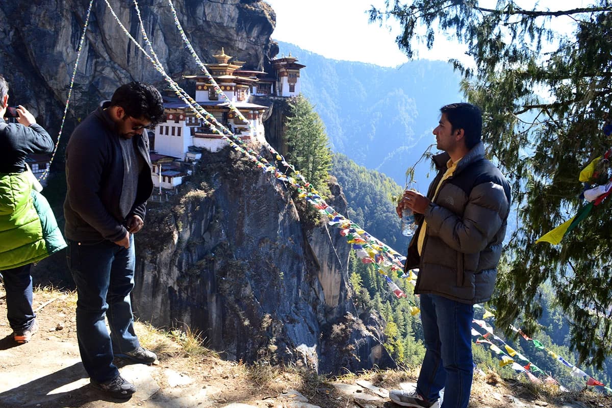
After breakfast excursion to Taktshang Monastery or Tiger’s Nest (approx. 5 hours walk):  It is one of the most famous of Bhutan’s monasteries, perched on the side of a cliff 900m above the Paro valley floor. It is said that Guru Rinpoche arrived here on the back of a tigress and meditated at this monastery and hence it is called ‘Tiger’s Nest’. This site has been recognised as a most sacred place and visited by ShabdrungNgawangNamgyal in 1646 and now visited by all Bhutanese at least once in their lifetime. On 19 April, 1998, a fire severely damaged the main structure of building but now this Bhutanese jewel has been restored to its original splendour.

Afternoon drive to DrukgyelDzong, a ruined fortress where Bhutanese warriors fought Tibetan invaders centuries ago. The snowy dome of sacred Chomolhari, "mountain of goddess'' can be seen in all her glory from the approach road to the Dzong. Along the way, visit the 7th century Kyichu Lhakhang, one of the 108 temples built in the Himalayas by Tibetan King, Songtsen Gampo. The building of this temple marks the introduction of Buddhism in Bhutan. Overnight at the hotel in Paro.

Meals: BLDAccommodation: Hotel

Snowman Trek is considered to be the most difficult trek in Bhutan. The attributes those make it a tough trek are; distances, altitudes, weather conditions and remoteness. Season: The Snowman trek is frequently closed because of snow and is almost impossible during winter. The recommended season for this trek is mid June to mid October.

After breakfast, drive to Gunitsawa Village to begin the trek. 40mins, 80 m descent, camp altitude 2,850 m. This trek begins at Gunitsawa Village were you pass the army post. At the army check-post your trek permit (provided by your tour operator) will be checked and endorsed. The campsite is on the opposite side of the river, not far from Gunitsawa.

Max Altitude: 3610 Meals: BLDAccommodation: Tented Camp

On this long day, the trail continues with lots of small ups and downs. After going uphill through the river valley the valley finally narrows gradually to a mere path which descends to a meadow where a camp will be set up. From here, if weather permits, you will have the first great view of Mt. Jomolhari.

Max Altitude: 4080 Meals: BLDAccommodation: Tented Camp

If you did not see Mt. Jomolhari the previous evening, you will still have a chance to get a great view early this morning. This morning the trek continues up the Paro Chhu valley which widens into patches of alpine meadow and scanty growths of forest. You will cross an army checkpoint along the way and enjoy a spectacular view of high mountain ridges and snow-capped peaks.

In this area yaks and their herder’s homes become a regular feature of the landscape. Passing the villages Soe, Takethang and Dangochang is another asset on this day. After reaching Jangothang, one of the most beautiful campsites of the Himalayas, you will again have a spectacular view of Mount Jomolhari.

Meals: BLDAccommodation: Tented Camp

The rest day in Jangothang provides plenty of possibilities for day hikes with great views of lakes and snow capped mountains such as Jomolhari and Jichu Drake. There are good chances to spot some blue sheep on the upper slopes of the valley. Jangothang is a perfect environment for your acclimatization. You can also trek up to Tosoh or hike around the area. There are good short hiking trails in three directions. Jomolhari and its subsidiary mountain chains lie directly west, Jichu Drake to the north and there are a number of unclimbed peaks to the east.

Max Altitude: 4010 Meals: BLDAccommodation: Tented Camp

This is one of the longest days of the trek.  A short distance from the camp the trail begins climbing rapidly for about half an hour and then becomes a gradual ascent to the Nyilila pass at 4,870m. While on the climb enjoy the surroundings. You might see herds of blue sheep grazing on the slopes of the mountains. From the pass you will have spectacular views of Mt. Jomolhari, Jichu Drake and Tsherimgang, all of them rising above 7,000m.

It's a gradual descent to the camp where you will pass by some of the yak herder’s tents, made from yak wool. The herders use these tents while travelling tovarious pastures for their yaks. As you come down into the Lingshi basin, a beautiful U-shaped valley, you get a wonderful view of Lingshi Dzong on clear days. Tserimgang and its glaciers rise up at the north end of the valley. The campsite is next to a stone hut you reach just before Lingshi Dzong.

Max Altitude: 3880 Meals: BLDAccommodation: Tented Camp

Today is the shortest walking day, and you can really take it easy. Shortly after starting you will reach a chorten below Lingshi Dzong. Here, you have the choice of staying on the main trail or taking a detour up to the Lingshi Dzong (4,220m), which sits right atop a high ridge.  This Dzong is under reconstruction from a 2011 earthquake which damaged its central building. In addition to a very special atmosphere of mystic tranquility, Lingshi Dzong provides a great view over the valley.

After Lingshi Dzong you will be passing the villages of Lingshi and Goyul. In Goyul, the stone houses are clustered together to form a small compact village that is unusual in Bhutan where settlements are usually scattered. On reaching the campsite at Chebisa you will have plenty of time to visit the village houses if you feel up to it. There is also a beautiful waterfall located behind the village that is worth visiting.

Max Altitude: 4220 Meals: BLDAccommodation: Tented Camp

The morning starts with a long ascent behind Chebisa Village (2-3 hours) through a wide pastureland towards Gobu La (pass). On the way, you will see a few people herding yaks. There is also a great chance to spot large herds of blue sheep above the trail. After crossing Gobu La (4,410m), you descend into the valley, then climb again a little bit, before descending again to Shakshepasa (3,980), a large U-shaped valley. Climbing from here you will finally reach the campsite at Shomuthang, above a river, which is a tributary of the Nochu river.

Max Altitude: 4160 Meals: BLDAccommodation: Tented Camp

You begin by climbing up the valley to view Kang Bum (6,526 m) and some edelweiss. After two hours of climbing you will reach Jhari La (4,750m), from where you catch the first glimpse of Sinche La, the pass you will have to cross the day after. The big snow peak in the north is Gangchhenta 6,840 m, better known as the Great Tiger Mountain. If weather is clear, Tserim Kang and the top of Jomolhari will be visible.

The camp by the river is called Tsheri Jathang located in a beautiful wide and remote valley. Herds of takin, the Bhutanese National Animal, migrate to this valley in summer and remain for about four months. The valley has been declared a takin sanctuary. Climb up a little bit and you will reach the campsite at Robluthang in a rocky meadow.

Max Altitude: 4140 Meals: BLDAccommodation: Tented Camp

The trek starts out with an initial 40-60mins ascent before gradually raising for another 1.5 hours through a boulder field.  It is then a 1 hour steep ascent before reaching Sinche La (5,005m) – the final and highest pass on the trek if you don’t intend to continue the Snowman trek from Laya onwards. 

As you descend the far side of the passyou will see an impressive terminal moraine and a glacial lake at the foot of the valley. You can see classic examples of lateral moraines where the glacier has pushed rocks up both sides of the valley. Below the moraine, you cross the Kango Chhu and soon reach the Limithang campsite. The peak of Gangchhenta towers over the campsite even though it’s quite a distance away.

Max Altitude: 4140 Meals: BLDAccommodation: Tented Camp

If you have trekked from Paro Valley you should spend a day recuperating from the trek to Laya and preparing yourself for the rest of this challenging but spectacular trek. If you have started from Gasa (Punakha) you should also walk up to Laya to acclimatize, and not just stay at the trail junction to Lunana. It’s worthwhile to spend one day in Laya just for the great views from Laya and its extroadinary inhabitants.

Max Altitude: 4160 Meals: BLDAccommodation: Tented Camp

From Laya we descend to an army camp and continue following the river till the turn off point to Rhoduphu. After lunch the climb continues through rhododendron bushes till you reach the camp at Roduphu just next to the Rhodu Chhu.

Max Altitude: 4900 Meals: BLDAccommodation: Tented Camp

After following the river for about half an hour you will have a steady climb to a high open valley at 4,600m and then further up to Tsomo La (4,900m). Tsomo La offers a superb view of Lunana, Mount Jomolhari and Jichu Drake, and the Tibetan border. The route then crosses a flat, barren plateau at about 5,000m. The campsite at Narethang is towered by the peak of Gangla Karchung (6,395m).

Max Altitude: 3970 Meals: BLDAccommodation: Tented Camp

From the camp you will climb for about an hour to Gangla Karchung La (5,120m). The view from the pass is breathtaking and the whole range of mountains including Jekangphu Gang (7,100m), Tsenda Kang and Teri Gang (7,300m) can be seen. The pass descends along a large moraine. Again one has great views: a massive glacier descends from Teri Kang to a deep turquoise lake at its foot. Up here a glacial lake burst through its dam in the early 1960s, causing widespread damage and partially destroying Punakha Dzong. Finally, it is a very long descent through thick rhododendron to Tarina valley, where you will find several good campsites along the Tang Chhu.

Max Altitude: 3910 Meals: BLDAccommodation: Tented Camp

The walk leads down through conifer forests following the upper ridges of the Pho Chhu, passing some impressive waterfalls. The trail then climbs over a ridge and drops to Woche, a settlement of a few houses, the first village in the Lunana region.

Max Altitude: 3700 Meals: BLDAccommodation: Tented Camp

The trek starts through juniper and fir forests, and further ahead, through rhododendron bushes. Climb up to Keche La pass (4,650m) where one can have the great view of surrounding mountains again. After the pass, descend to the riverside walking through a village with a stunning view of Table Mountain and others. Follow up the river till Lhedi Village. Lhedi has a basic health unit, a school and a wireless telephone connection.

Max Altitude: 4150 Meals: BLDAccommodation: Tented Camp

In clear weather, you will have great views of Table Mountain (7,100m).  Around lunchtime you will pass the small village of Chozo (4,090m) which has a dzong still in use. Reaching Thanza again you will have a great view of Table Mountain which forms a 3,000m high wall of snow and ice behind the village. Although there are possibilities to camp directly at Thanza, most groups prefer to camp in Thoencha.

Max Altitude: 4150 Meals: BLDAccommodation: Tented Camp

In Thanza walk around and experience some village life or climb up the ridge for fascinating views of lakes and mountains. But as it takes time to arrange new yaks (the yaks from Laya will not go further than Thanza) you might have to spend one day at Thanza anyway.

Max Altitude: 5120 Meals: BLDAccommodation: Tented Camp

Having chosen the route to Bumthang the trek starts by climbing a ridge with a great view of Table Mountain and Thanza valley below. The ridge altitude is 4,500m and it rises gradually up to 4,650m. After lunch, walk upwards towards the left side of the bridge to enjoy the view of snow-capped mountains. You reach the campsite of Tshorim after climbing more ridges.

Meals: BLDAccommodation: Tented Camp

This is one of the highlights of the trek and the day starts with a short climb to the Tshorim Thso. You walk on the side of the lake enjoying a panoramic view of the Gophu La ranges. The last climb to the Gophu La pass (5,230m) is very short. After the pass descend to the base camp, walking along the ridge to enjoy a great view of Gangkhar Puensum. If interested, one can divert to the left side to climb up the pyramid peak for a better view or you can go down to the base camp nearby Sha Chhu.

Max Altitude: 4200 Meals: BLDAccommodation: Tented Camp

The trail further follows the Sha Chhu and descends gradually to Geshe Woma.

Max Altitude: 4000 Meals: BLDAccommodation: Tented Camp

The path continues following Sha Chhu for two and a half hours until the stiff climb to Saka La begins. Visibility along the Saka La trail is poor so one must see top of the ridge for guidance. After having lunch nearby a yak herders’ camp you climb up to Saka La (4,800m). The path then descends to a couple of lakes and another short ascent is stunning. Scenery once again is beautiful with small lakes and the mountain peaks.

Max Altitude: 3590 Meals: BLDAccommodation: Tented Camp

A one hour climb leads to Juli La (4,700m). After the pass, you descend to the riverside through dense rhododendron, juniper and conifer forests. After the bridge a short climb leads to Duer Tsachu. These hot springs, where Guru Padmasambhava is supposed to have taken bath, might be the most stunningly beautiful hot springs of the Himalayas. You might want to spend an extra day at Duer Tsachu.

Max Altitude: 3850 Meals: BLDAccommodation: Tented Camp

From the hot springs it is a long and steady climb again with great views of mountains in Lunana. You will also come across blue lakes and yak herder huts.

Max Altitude: 2800 Meals: BLDAccommodation: Hotel

This is the last day of the trek and your porters change from yaks to horses. The path follows the Chamkhar Chhu, descending gradually with a few climbs in between. The trek ends here when you arrive at Duer village. From here you drive to Jakar (Bumthang). Overnight at the hotel at Bumthang

Max Altitude: 2800 Meals: BLDAccommodation: Hotel

After breakfast, full day is at leisure or indulge with Bumthang sightseeing. Visit Kurje Lhakhang, where the saint Padma sambhava subdued a local demon and left his body imprint on a rock, the Jambey Lhakhang (7th century temple), Tamshing Lhakhang (housing some of the oldest wall paintings in Bhutan) and Jakar Dzong (administrative center of the region). Stroll in the village, visit the little handicrafts shop at the entrance to the town, and perhaps take refreshments at a local restaurant.

Afternoon take a short hike to Lhodrak Kharchhu Monastery: Located above the main town, about 3 km from Chamkhar town, the monastery was founded by Namkhai Nyingpo Rinpoche in 1984 who was recognized at a very young age by H.H. the 14th Dalai Lama and H.H. 16th Karmapa as the reincarnation of a Tibetan lama. The monastery has become part of an extensive effort to preserve and revitalize Tibetan culture.

The monk regular curriculum includes reading, memorizing the daily prayers, learning dharma dances, drawing mandalas, learning the melodies of sacred rituals, learning the use of ceremonial instruments and the art of making sacrificial objects, grammer, poerty, karika along with the basics of contemplation and instruction on the different stages of tantra. Overnight at Hotel in Bumthang

Max Altitude: 3000 Meals: BLDAccommodation: Hotel

Morning after breakfast drive to Trongsa over the Yutong-la pass (3,400m/ 11,155 ft), enroute visiting Chumey valley and Yathra (woollen fabric) weaving center and villages. Later visit to Trongsa Dzong, built in 1648 it was the seat of power over central and eastern Bhutan. Both the first and second Kings of Bhutan ruled the country from this ancient seat. All four Kings were invested as Trongsa Penlop (‘governer’) prior to ascending the throne, and the present Crown Prince now holds the post.

The Dzong is a massive structure with many levels, sloping down the contours of the ridge on which it is built. Upon arrival at Gangtey; check into the hotel. The valley of Gangtey is one of the most beautiful spots in Bhutan. The surprise of finding such a wide, flat valley without any trees after the hard climb through dense forests is augmented by an impression of vast space, and extremely rare experience in Bhutan where most of the valleys are tightly enclosed. Evening take a stroll around fascinating Gangtey Village. Overnight at the hotel in Gangtey

Max Altitude: 3000 Meals: BLDAccommodation: Hotel

After breakfast, proceed to visit Gangtey Goempa, perched on a small hill that rises from the valley floor, the Gangtey Monastery is the only Nyingmapa monastery on the western side of the Black Mountain’s and also the biggest Nyingmapa monastery in Bhutan. The Monastery is surrounded by a large village inhabited mainly by the families of the 140 Gomchens who take care of the Monastery. Later explore fascinating Phobjikha valley.

A few kilometers beyond the Gangtey Monastery, on the valley floor lies the village of Phobjikha. This quite, remote valley is the winter home of black necked cranes, which migrate from the arid plains of Tibet in the north, to pass the winter months in a milder climate. Phobjikha, at an altitude of 2900 m, falls under the district of Wangdue Phodrang and lies on the periphery of the Black Mountain National Park. The valley boasts two beautiful meandering rivers, Nakay Chhu (Chhu Naap-black water) and Gay Chhu (Chhu Karp-white water). According to a local legend, the two rivers actually represent a snake and a boar.

The two animals once raced each other with an agreement that if the snake (Nakay Chhu) won, Phobjikha valley would be able to grow rice, but if the boar won, then rice could never be cultivated in the area. The snake lost since it had to meander all the way during its journey. Rice cannot be cultivated in the valley even today. Also visit Black Necked Crane Information Centre: Situated on the edge of the forest and wetland along the main road of Phobjikha valley, the black-necked crane information Centre has an observation room equipped with high power telescope and spotting scopes for catching the best view of the cranes.

The centre also offers display information that outline the natural and cultural history of the area. There is a small gift shop, which sells handicrafts produced by the local people. Overnight at the hotel in Gangtey

Max Altitude: 1250 Meals: BLDAccommodation: Hotel

After breakfast, check-out from the hotel and drive to Punakha, the old capital town of Bhutan. After checking into hotel, proceed to visit Punakha Dzong, a massive structure built at the junction of two rivers. It was the capital of Bhutan until 1955, and still serves as the winter residence of the monk body. Further visit to Chimi Lhakhang (from hotel it is about 15 mins drive till motor able road and then walk starts through paddy fields and villages. This is total about 1.1/2 hour walk, including both way).

The Chimi Lhakhang, situated on a hillock in the centre of the valley, also known as the temple of fertility. It is widely believed that couples who do not have children and wanting one, if they pray at this temple, they are usually blessed with a child very soon. The trail leads across rice fields to the tiny settlement of Pana, meaning ‘field’. Overnight at the hotel in Punakha

Max Altitude: 2400 Meals: BLDAccommodation: Hotel

Morning after breakfast drive to Thimphu via Dochu-la pass (3,088m/ 10,130 ft) stopping briefly here to take in the view and admire the chorten, mani wall, and prayer flags which decorate the highest point on the road. If skies are clear, the following peaks can be seen from this pass (left to right): Masagang (7,158m), Tsendagang (6,960m), Terigang (7,060m), Jejegangphugang (7,158 m ), Kangphugang (7,170 m ), Zongphugang (7, 060 m ), a table mountain that dominates the isolated region of Lunana - finally Gangkar puensum, the highest peak in Bhutan at 7,497m. On arrival, in Thimphu check-into the hotel.

The capital town of Bhutan and the centre of government, religion and commerce, Thimphu is a unique city with unusual mixture of modern development alongside ancient traditions. With the population of about 90,000 it is perhaps still the world’s only capital city without a traffic light. Evening an exploratory walk around Thimphu Main Street and as time permit, visit interesting weekend market of Thimphu. Overnight at the hotel in Thimphu.

Max Altitude: 2400 Meals: BLDAccommodation: Hotel

After breakfast, sightseeing in Thimphu valley including visit to the following: The National Library, housing an extensive collection of priceless Buddhist manuscripts; the Institute for Zorig Chusum (commonly known as the Painting School) where students undergo a 6-year training course in Bhutan’s 13 traditional arts and crafts. Later visit Textile Museum, which provides insight into Bhutan’s one of the most distinct art form. Also visit Simply Bhutan, a living museum and studio encapsulating the cultural heritage of the Bhutanese people. After lunch, take a short drive (15 km) to Pangri Zampa, 16th century one of the oldest monasteries in Bhutan located just north of Thimphu.

Here is a monastic school where Buddhist student’s monks learn Lamaism and astrology based on Buddhist philosophy. Afterwards visit to Buddha Point (Kuensel Phodrang). Located at a short drive from Thimphu city centre, visitors can get a good overview of the Thimphu valley from the Buddha point (KuenselPhodrang). You can pay your obeisance and offer prayers to the Buddha, the largest statue in the country and then walk around and take a glimpse of the valley. King's Memorial Chorten continuously circumambulated by people, murmuring mantras and spinning their prayer wheels.

Construction of this landmark was the idea of Bhutan’s third king, His Majesty Jigme Dorji Wangchuk (“the father of modern Bhutan”) who has wished to erect monument to world peace and prosperity. Completed in 1974 after his untimely death, it serves both as a memorial to the Late King and as a monument to peace. Later visit to Trashichhoedzong: This impressive fortress/monastery houses Secretariat building, the throne room of His Majesty, the King and various government offices. It is also the summer residence of Chief Abbot and central monk body. Overnight at the hotel in Thimphu

Meals: Breakfast

After early breakfast at the hotel, drive to Paro airport for flight to your onward destination. Our representative will help you with exit formalities and then bid you farewell.

Couldn't find what you're afterReach out to our travel experts.
Essential Information

The recommended best seasons for Snowman Trek in Bhutan:

October to November: This is considered the best time to trek as the weather is clear and the temperature is moderate.

December to January: This is another good time to trek, however, the temperature is quite low and the trail may be icy.

February to June: This is the pre-monsoon season and can be good for trekking, but it can be quite wet.

It is important to note that the Snowman Trek is considered one of the most challenging treks in the world and can only be attempted by experienced trekkers.

Need Help? Call Us.+977 9851162422